
This book contains exercises for a physical geology lab class. It is under development, with a full 1st edition release planned for Fall 2024.
The goals of this chapter are:
- Understand evolution of rocky planets
- Compare various physical features seen on Earth with other planets
- Evaluate relative ages on planets
Recent planetary missions by NASA, the European Space Agency and other space agencies have confirmed that geological processes you have investigated on Earth also help create rocky planets and moons. Common processes link the internal structure and landscapes of both rocky and icy worlds as well as volcanoes, impact craters, ice caps, dunes, faults, rivers and oceans as features of extra-terrestrial worlds as diverse as Venus and Io. Each new mission to space reveals that many supposedly dead planetary bodies currently experience eruptions, landslides and dust storms. Moreover our understanding of the Solar System has increased by studying meteorites from asteroids and Mars as well as rock samples collected on the Moon.
Rocky planets (or terrestrial planets) are relatively small when compared to the Gas Giants or many of the recently discovered exoplanets. Rocky planets have solid surfaces, often pock marked by impacts seen as craters. These don’t have rings with few or no moons. They may have evidence of past or current tectonic as well as volcanic activity. As on Earth, the rock cycle explains how the three rock types relate to each other, and the process of how they change over time. We’ve spent a lot of time talking about the rocks on Earth, but do other planets have rock cycles?
Let’s look at Mars, sometimes called the Red Planet, which is the fourth planet from the Sun. Mars has some Earth-type characteristics, such as polar ice caps, mountains, sand dunes, and clouds. It is by far the planet most visited by spacecraft in our solar system. As of 2024, 21 lander missions and 8 sub-landers (rovers and penetrators) attempted to land on Mars. Of 21 landers, the Curiosity and Perseverance rovers are currently still in operation on Mars. Curiosity rover has long outlived its expected mission as it has been roaming the surface of Mars for over 11 years!
Exercise 14.1 – Martian Rock Cycle
Today, Mars is no longer volcanically or tectonically active. However, remnants of Mars’ massive volcanoes remain (Figure 14.1). Its most recent eruption is estimated to have occurred only 20 million years ago. To distinguish features on planets from those on Earth, mountains are called Mons (singular) or Montes (plural).

- Tharsis Montes are three enormous volcanoes located within the Tharsis region of Mars. These volcanoes form a straight line each other and align with other volcanoes in the region such as Ceraunius Tholus and Uranius Mons. What does this chain of volcanoes in the Tharsis region suggest about volcanic and tectonic history of this region?
- Figure 14.2 is a picture of an igneous rock taken by NASA’s Curiosity Mars rover. The light-colored, elongated crystals are likely feldspar; some are 1 cm in size. The dark-colored matrix surrounding the feldspar is pyroxene.
- Describe the texture and cooling history of the rock.
- Is this rock felsic, intermediate, mafic, or ultramafic? How can you tell?
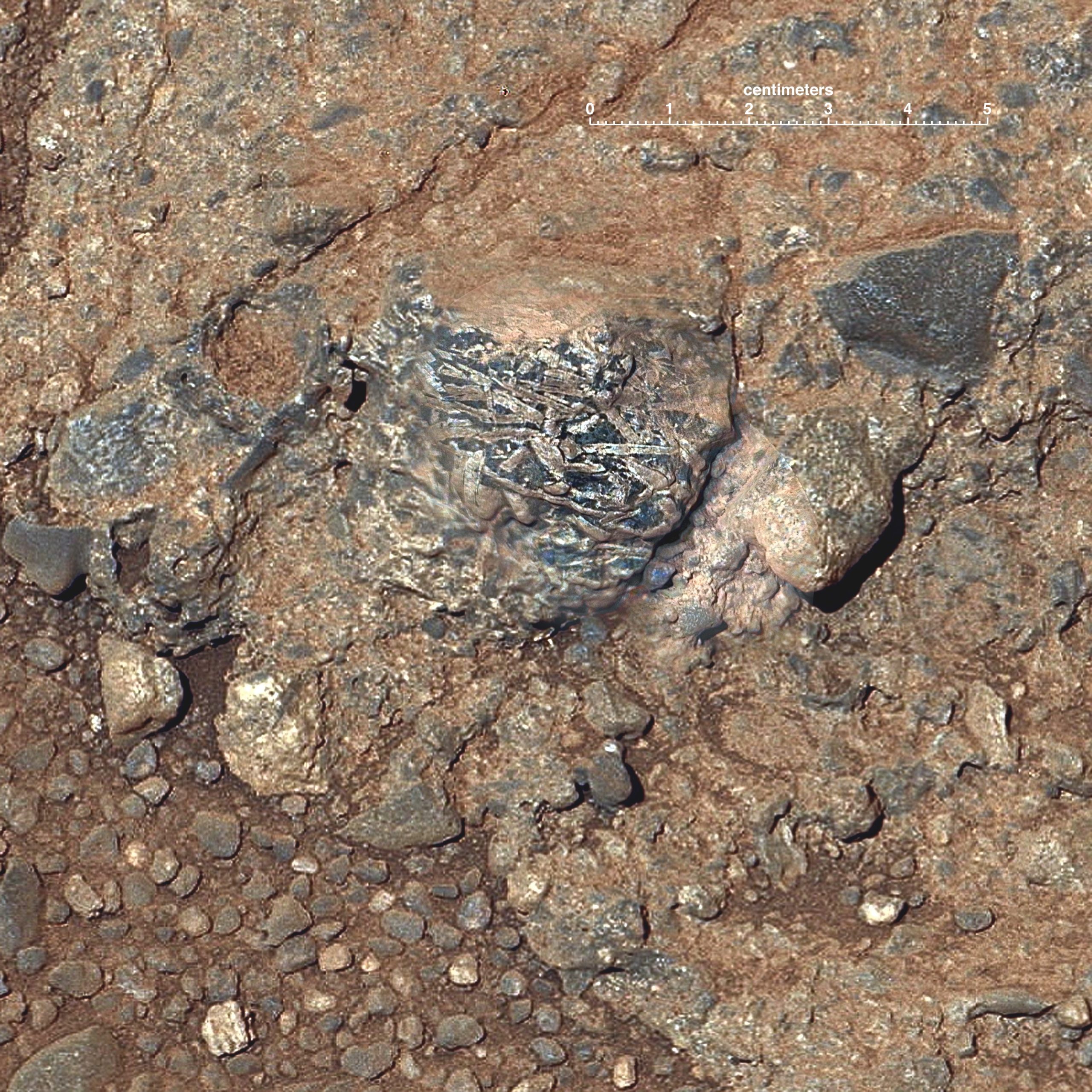
Figure 14.2 – Martian rock ‘Harrison’ from inside Gale crater on the lower slope of Mount Sharp. Created by merging images from two cameras on NASA’s Curiosity Mars rover. Annotated figure includes a scale bar in the upper right. Image credit, NASA, Public Domain.
- Describe the texture and cooling history of the rock.
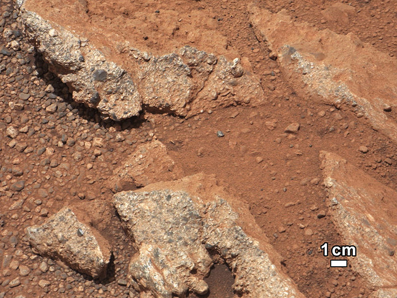
- Figure 14.3 is a picture of a sedimentary rock taken by NASA’s Curiosity rover.
- Describe the texture of the rock.
- How much energy is needed to transport the pebbles?
- Today, the main mechanism for sediment transport on Mars is wind. What features do you see that either support or don’t support this method of sediment transport?
- If this rock were from Earth, what type of environment would you find it?
- What does this imply about Mars’s geologic history?
- At present, could there be water on Mars?

Figure 14.3 – Image of the Martian rock “Link” taken by the Mars Curiosity Rover. The color was changed to resemble conditions on Earth. Image credit: NASA, Public Domain.
- Describe the texture of the rock.
- Do you think we could find metamorphic rocks on Mars? Use Figures 14.4 and 14.5 to help.
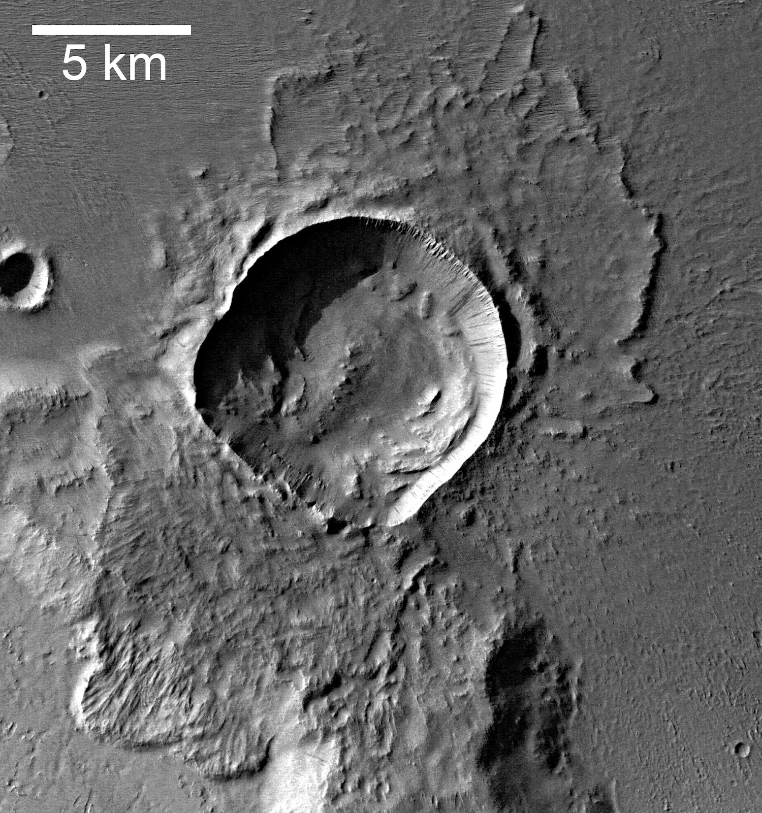
Figure 14.4 – A photograph of an impact crater from Mars taken form the European Space Agency’s Mars Express spacecraft. Image credit. ESA/DLR/FU Berlin, CC BY-SA IGO.

Exercise 14.2 – Lunar Geology and relative time
Figures 14.5 and 14.6 are topographic maps of lowlands (mare) and highlands of the moon, respectively.
- Determine the relative age of these two areas.
- Mare (lowlands) surface age: ____________________
- Highlands surface age: ____________________
- Now explore the
Exercise 14.3 – Relative Dating on Mars
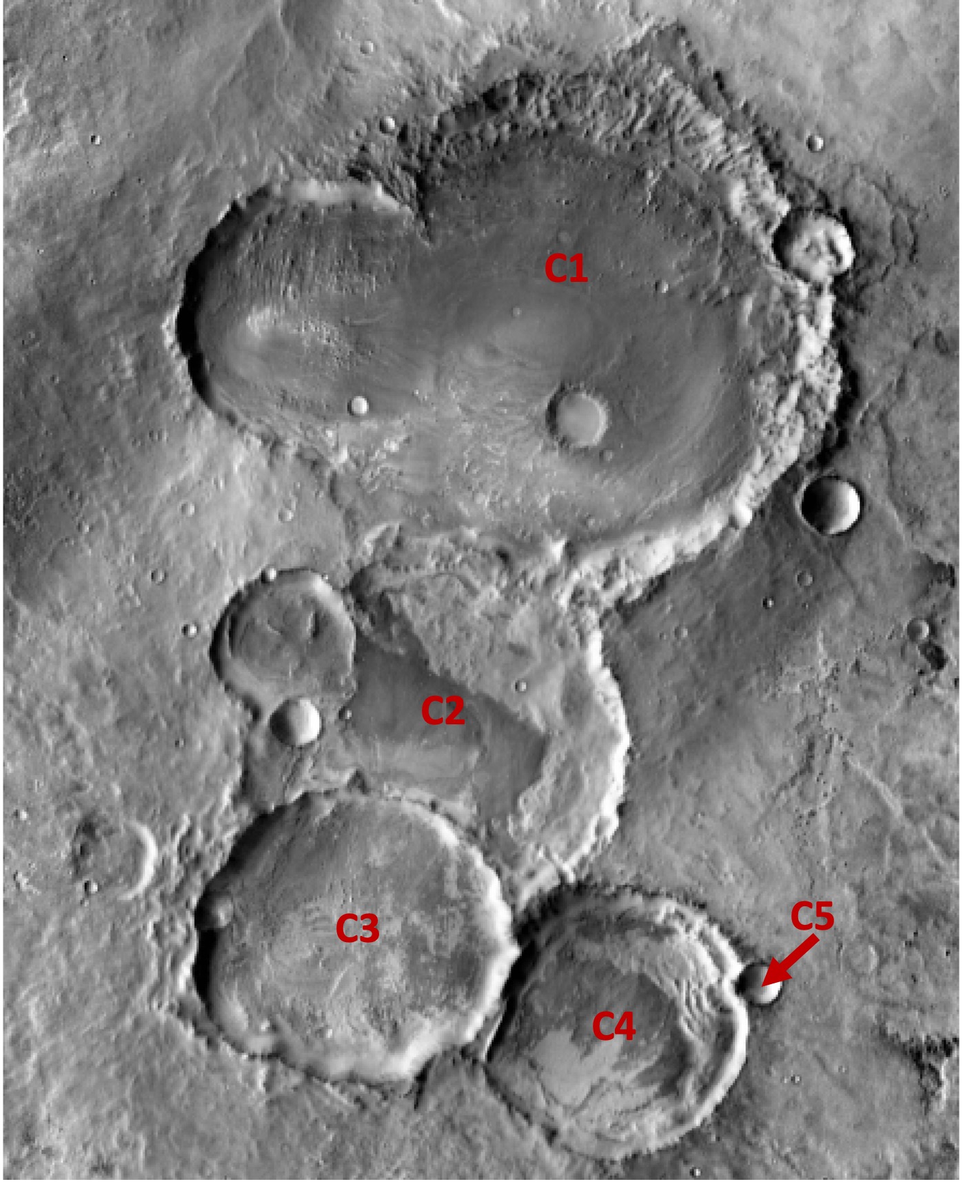
Cross-cutting relationships is a principle in geology used to decipher the relative ages of rocks and geologic features. This principle is based on the concept that a rock or feature must be younger than any rock or feature it cuts across. We can apply this principle to determine the relative ages of features on other planetary bodies. In this exercise, we will look at images of the surface of Mars and apply the principle of cross-cutting relationships to determine the relative ages of different geologic features.
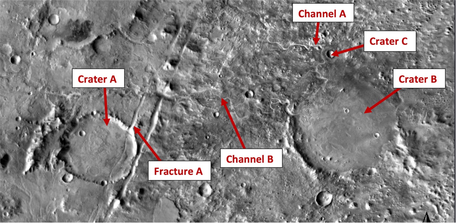
Figure 14.8 is a Google Earth image from Mars that shows craters, fractures, and river channels. Use the principle of cross-cutting relationships to answer the following questions.
- Which is older, Crater A or Fracture A? How can you tell?
- Which is older, Crater B or Channel A? How can you tell?
- Is Crater C younger or older than Crater B? How can you tell?
- If Channel B cuts through both Crater B and Fracture A, is Crater A younger of older than Crater B?
- Look at Figure 14.9. Arrange the craters in relative order from oldest to youngest.
Exercise 14.4 – Winds and Dunes in our Solar System
Dunes are classified by the amount of sand and wind direction (Figure 14.X). On Earth, vegetation also influences dune morphology, but in the rest of the solar system, vegetation is not an issue. Sand refers to grain size and is just a small solid particle, which can be quartz or even solid methane if you are in the outer solar system.
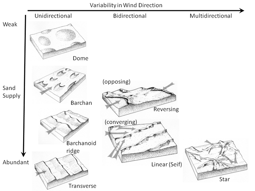
Planetary geologists have identified dunes on Earth, Venus, Mars, Titan (moon of Saturn), Triton (moon of Neptune), Io (moon of Jupiter), and Pluto as well as one comet. To interpret these, look for shadows on the dunes. This is the steep versus gentle slope on the dune. The steep side will be the downwind side for barchan, transverse, barchanoid, and star dunes. When looking at these images, you must ignore the features that are not dunes, such as hills, mesas, buttes, craters, etc.
- Figure 14.11 shows several dunes from Mars. Determine the dune type, number of wind directions, and relative amount of sediment for each. Complete Table 14.2.
14.2 – Martian Dune Data Location Dune type # of wind directions Sediment amount Impact Crater Chasma Boreale (85° N) Frosty Dunes (76° N) 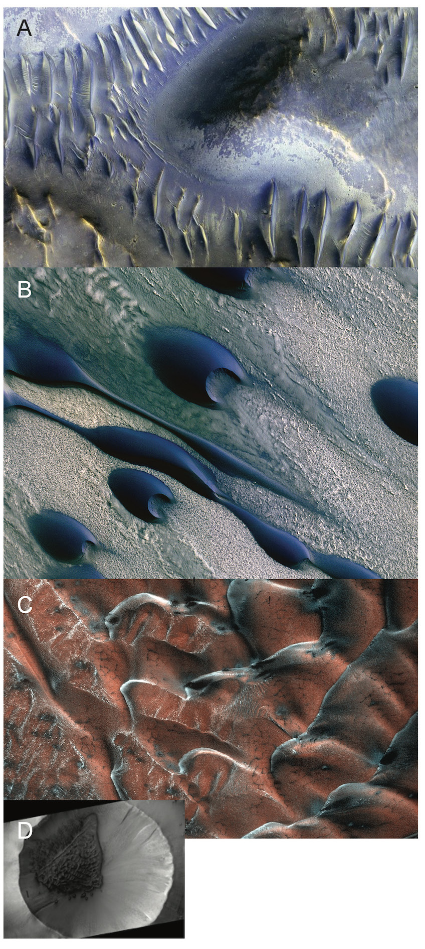
Figure 14.11 – Various dunes from Mars. A) Dunes inside an impact crater on Mars. There is a mound in the center that appears to have blocked the dunes. This may have caused wind shifts in this area. B) Dunes north polar ice cap in the Chasma Boreale region. The white areas show irregular polygonal patterns developed in carbon dioxide ice (dry ice). The dunes are made of basalt and gypsum grains. C) Frosty sand dunes on Mars. The frost is carbon dioxide ice. These occur inside a crater (see D) in the northern plains of Mars. Image credits: These images are false-colors by NASA/JPL-Caltech/UArizona, Public Domain. - Now look at dunes from elsewhere in the solar system (Figure 14.12). Complete Table 14.3 with the type of dune, number of wind directions, and the amount of sediment.
Table 14.3 – Solar System Dune Data Planetary Body Dune type # of wind directions Sediment amount Comet (A) Venus (B) Venus (C) Io (D) Titan (E) Pluto (F) - Now that you’ve analyzed dunes from several places throughout the solar system, let’s see if you make any generalizations about winds and sediment supply on the various planets. List which planets show only one direction of wind.
- Which planets have more than one direction of wind?
- Is the sediment supply the same in the different Martian examples? Rank them from most to least amount of sediment.
- Even though these images are very different scales, rank the relative amount of sediment on each planet from most to least.
- How does the sediment supply vary between the different planets and moons?
- Critical Thinking: Which of these dunes fields is where you would like to go explore? Just choose one and explain why you chose that place.

Additional Information
Exercise credit
References
Hare, T.M, R.K. Hayward, J.S. Blue, and B.A. Archinal, 2015, Image mosaic and topographic map of the moon, 2 sheets, U.S. Geological Survey Scientific Investigations Map 3316, doi:10.3233/sim3316
